POP

Plateforme ouverte du patrimoine

Rue Penher Le Goff (Baud)

Désignation

Dénomination de l'édifice

Rue

Appellation d'usage

Penher Le Goff

Titre courant

Rue Penher Le Goff (Baud)

Localisation

Localisation

Bretagne ; Morbihan (56) ; Baud ; Penher Le Goff (rue)

Aire d'étude pour le domaine Inventaire

Baud

Canton

Baud

Adresse de l'édifice

Penher Le Goff (rue)

Références cadastrales

2000 AH

Milieu d'implantation pour le domaine Inventaire

En ville

Historique

Siècle de la campagne principale de construction

16e siècle ; 19e siècle ; 20e siècle

Description historique

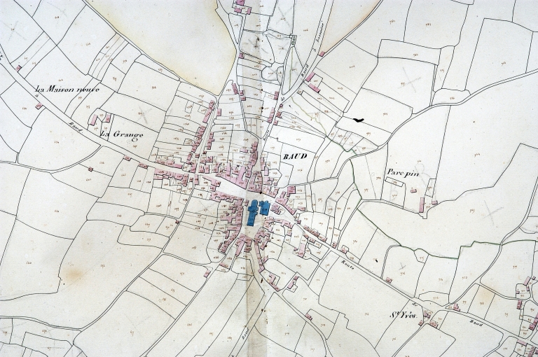
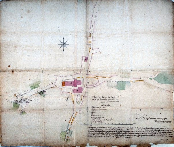
La rue Penher Le Goff, pendant de la rue du Malberh, est un itinéraire ancien figurant sur le plan de Detaille en 1784. Elle part de la route de Pontivy vers l'est après la place du marché. Les vestiges d'une maison du 16e siècle forment aujourd'hui une partie du mur sud de l'enceinte du collège. Les autres maisons repérées ont toutes été reconstruites sur des parcelles anciennes au 19e siècle.

Description

Commentaire descriptif de l'édifice

Rue orientée est-ouest. Deux maisons y ont été repérées, ainsi que le mur de façade d'une maison du 16e siècle et le collège.

Protection et label

Observations concernant la protection de l'édifice

Située à la jonction des deux axes qui sont à l'origine de la formation du bourg et siège des anciennes halles, la place du Marché est un élément structurant majeur de la ville.

Statut juridique

Statut juridique du propriétaire

Propriété publique

Références documentaires

Date de l'enquête ou du dernier récolement

2002

Date de rédaction de la notice

2005

Noms des rédacteurs de la notice et du dossier

Tanguy Judith ; Toscer Catherine

Typologie du dossier

Sous-dossier

Adresse du dossier Inventaire

Région Bretagne - Service de l'Inventaire du Patrimoine Culturel - 283 avenue du général Patton - CS 21101 - 35711 Rennes Cedex 7 - 02.22.93.98.35

1/3
Plan cadastral 1829, section AH (AD Morbihan, série 3P) ; Plan cadastral 1829, section AH (AD Morbihan, série 3P) ; Plan cadastral 1829, section AH (AD Morbihan, 3P) ; Plan cadastral 1828. Section (AD Morbihan, 3P) ; Plan cadastral 1829, section AH (AD Morbihan, série 3P) ; Plan cadastral 1829, section AH (AD Morbihan, série 3P) ; Plan cadastral 1829, section AH (AD Morbihan, série 3P) ; Extrait du cadastre ancien de 1829, section AH (A.D. Morbihan, série 3P) ; Plan cadastral 1829, section AH (AD Morbihan, série 3P) ; Plan cadastral 1829, section AH (AD Morbihan, série 3P) ; Plan cadastral 1829, section AH (AD Morbihan, série 3P) ; Plan cadastral 1829, section AH (AD Morbihan, série 3P) ; Plan cadastral 1829, section AH (AD Morbihan, série 3P) ; Plan cadastral 1829, section AH (A.D. Morbihan, série 3P) ; Plan cadastral 1829, section AH (AD Morbihan, série 3P) ; Plan cadastral 1829, section AH (AD Morbihan, série 3P) ; Plan cadastral 1829, section AH (AD Morbihan, série 3P) ; Plan cadastral 1829, section AH (AD Morbihan, série 3P) ; Plan cadastral 1829, section AH (AD Morbihan, série 3P) ; Plan cadastral 1828. Section (AD Morbihan, 3P) ; Plan cadastral 1829, section AH (AD Morbihan, série 3P) ; Plan cadastral 1829, section AH (AD Morbihan, série 3P) ; Plan cadastral 1829, section AH (AD Morbihan, série 3P) ; Le bourg, extrait du plan cadastral de 1829, section AH (A.D. 56, série 3P)
(c) Inventaire général, ADAGP
Voir la notice image
Plan de la ville par Detaille de Keroyand, 1784. (AD Morbihan) ; Plan de la ville par Detaille de Keroyand, 1784. (AD Morbihan) ; Plan de la ville par Detaille de Keroyand, 1784 (AD Morbihan, série 1 Fi 116) ; Plan de la ville par Detaille de Keroyand, 1784. (AD Morbihan) ; Plan de la ville par Detaille de Keroyand, 1784. (AD Morbihan) ; Plan de la ville par Detaille de Keroyand, 1784. (AD Morbihan) ; Plan de la ville par Detaille de Keroyand, 1784. (AD Morbihan) ; Plan de la ville par Detaille de Keroyand, 1784. (AD Morbihan) ; Plan de la ville par Detaille de Keroyand, 1784. (AD Morbihan) ; Plan de la ville par Detaille de Keroyand, 1784. (AD Morbihan) ; Plan de la ville par Detaille de Keroyand, 1784. (AD Morbihan) ; Plan de la ville par Detaille de Keroyand, 1784. (AD Morbihan) ; Plan de la ville par Detaille de Keroyand, 1784. (AD Morbihan)
(c) Inventaire général, ADAGP
Voir la notice image
Maison, type ternaire, variante à 5 travées, vers 1860. Section AH, parcelle 209
(c) Inventaire général, ADAGP
Voir la notice image