POP

Plateforme ouverte du patrimoine

Rue d'Auray, puis rue du Pont de Baud (Baud)

Désignation

Dénomination de l'édifice

Rue

Appellation d'usage

D'Auray

Titre courant

Rue d'Auray, puis rue du Pont de Baud (Baud)

Localisation

Localisation

Bretagne ; Morbihan (56) ; Baud ; Auray (rue d') ; Pont de Baud (rue du)

Aire d'étude pour le domaine Inventaire

Baud

Canton

Baud

Adresse de l'édifice

Auray (rue d') ; Pont de Baud (rue du)

Références cadastrales

2000 AH

Milieu d'implantation pour le domaine Inventaire

En ville

Partie constituante non étudiée

Mairie

Historique

Siècle de la campagne principale de construction

18e siècle ; 19e siècle ; 20e siècle

Description historique

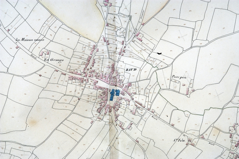
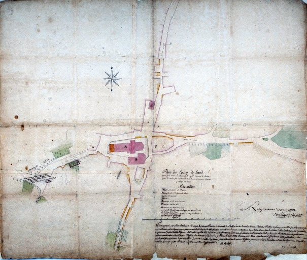
Cette rue qui figure sur le plan de Detaille en 1784 comme un simple chemin, est la conséquence de la modification de l'itinéraire Pontivy- Auray, qui à partir du 19e siècle, emprunte au départ la route allant vers Hennebont et Lorient. Le plan cadastral de 1829 ne montre qu'une maison, sans doute une ferme, contruite le long de la rue. La majorité des maisons conservées le long de cet axe datent de la fin du 19e siècle et du 20e siècle.

Description

Commentaire descriptif de l'édifice

Rue aujourd'hui large, mais très étroite sur le cadastre ancien. 22 (chiffre à revoir) maisons y ont été repérées.

Statut juridique

Statut juridique du propriétaire

Propriété publique

Références documentaires

Date de l'enquête ou du dernier récolement

2002

Date de rédaction de la notice

2005

Noms des rédacteurs de la notice et du dossier

Tanguy Judith ; Toscer Catherine

Typologie du dossier

Dossier individuel

Adresse du dossier Inventaire

Région Bretagne - Service de l'Inventaire du Patrimoine Culturel - 283 avenue du général Patton - CS 21101 - 35711 Rennes Cedex 7 - 02.22.93.98.35

1/3
Plan cadastral 1829, section AH (AD Morbihan, série 3P) ; Plan cadastral 1829, section AH (AD Morbihan, série 3P) ; Plan cadastral 1829, section AH (AD Morbihan, 3P) ; Plan cadastral 1828. Section (AD Morbihan, 3P) ; Plan cadastral 1829, section AH (AD Morbihan, série 3P) ; Plan cadastral 1829, section AH (AD Morbihan, série 3P) ; Plan cadastral 1829, section AH (AD Morbihan, série 3P) ; Extrait du cadastre ancien de 1829, section AH (A.D. Morbihan, série 3P) ; Plan cadastral 1829, section AH (AD Morbihan, série 3P) ; Plan cadastral 1829, section AH (AD Morbihan, série 3P) ; Plan cadastral 1829, section AH (AD Morbihan, série 3P) ; Plan cadastral 1829, section AH (AD Morbihan, série 3P) ; Plan cadastral 1829, section AH (AD Morbihan, série 3P) ; Plan cadastral 1829, section AH (A.D. Morbihan, série 3P) ; Plan cadastral 1829, section AH (AD Morbihan, série 3P) ; Plan cadastral 1829, section AH (AD Morbihan, série 3P) ; Plan cadastral 1829, section AH (AD Morbihan, série 3P) ; Plan cadastral 1829, section AH (AD Morbihan, série 3P) ; Plan cadastral 1829, section AH (AD Morbihan, série 3P) ; Plan cadastral 1828. Section (AD Morbihan, 3P) ; Plan cadastral 1829, section AH (AD Morbihan, série 3P) ; Plan cadastral 1829, section AH (AD Morbihan, série 3P) ; Plan cadastral 1829, section AH (AD Morbihan, série 3P) ; Le bourg, extrait du plan cadastral de 1829, section AH (A.D. 56, série 3P)
(c) Inventaire général, ADAGP
Voir la notice image
Plan de la ville par Detaille de Keroyand, 1784. (AD Morbihan) ; Plan de la ville par Detaille de Keroyand, 1784. (AD Morbihan) ; Plan de la ville par Detaille de Keroyand, 1784 (AD Morbihan, série 1 Fi 116) ; Plan de la ville par Detaille de Keroyand, 1784. (AD Morbihan) ; Plan de la ville par Detaille de Keroyand, 1784. (AD Morbihan) ; Plan de la ville par Detaille de Keroyand, 1784. (AD Morbihan) ; Plan de la ville par Detaille de Keroyand, 1784. (AD Morbihan) ; Plan de la ville par Detaille de Keroyand, 1784. (AD Morbihan) ; Plan de la ville par Detaille de Keroyand, 1784. (AD Morbihan) ; Plan de la ville par Detaille de Keroyand, 1784. (AD Morbihan) ; Plan de la ville par Detaille de Keroyand, 1784. (AD Morbihan) ; Plan de la ville par Detaille de Keroyand, 1784. (AD Morbihan) ; Plan de la ville par Detaille de Keroyand, 1784. (AD Morbihan)
(c) Inventaire général, ADAGP
Voir la notice image
N°8. Ancienne poste. Maison d'angle, désenduite. Elévation est sur rue. Section AH, parcelle 488
(c) Inventaire général, ADAGP
Voir la notice image