POP

Plateforme ouverte du patrimoine

Eglise paroissiale Saint-Pierre, place Le Sciellour (Baud)

Désignation

Dénomination de l'édifice

Église paroissiale

Vocable - pour les édifices cultuels

Saint-Pierre

Titre courant

Eglise paroissiale Saint-Pierre, place Le Sciellour (Baud)

Localisation

Localisation

Bretagne ; Morbihan (56) ; Baud ; Le Sciellour (Place)

Aire d'étude pour le domaine Inventaire

Baud

Canton

Baud

Adresse de l'édifice

Le Sciellour (Place)

Références cadastrales

2005 AH 322

Milieu d'implantation pour le domaine Inventaire

En ville

Historique

Siècle de la campagne principale de construction

16e siècle (?) ; 4e quart 17e siècle ; 4e quart 18e siècle

Année(s) de(s) campagne(s) de construction

1687 ; 1793

Commentaires concernant la datation

Daté par travaux historiques ; daté par travaux historiques

Description historique

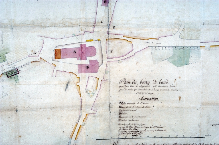
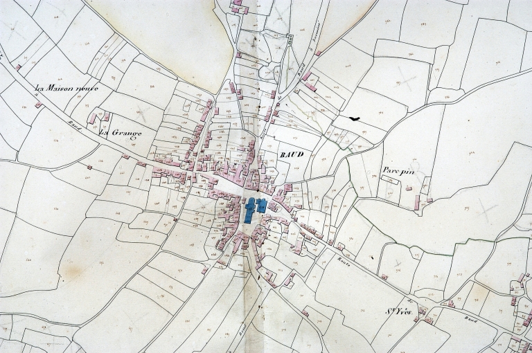
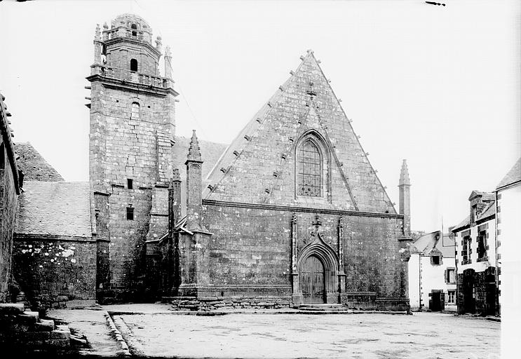
L'église paroissiale Saint-Pierre s'élevait parallèlement à la chapelle Notre-Dame de la Clarté, au nord, avant son effondrement et sa destruction en 1922. Le choeur de cet édifice ancien, peut-être du 16e siècle, est reconstruit en 1687 sous le rectorat de Louis de Lantivy. Un siècle plus tard, en 1793, la nef est agrandie et une nouvelle façade est construite. Malgré ces rénovations, la nef s'effondre en 1922 et l'édifice est rasé. Une nouvelle nef est reconstruite en 1927, raccordée à la façade nord de la chapelle Notre-Dame de la Clarté. Le plan d'alignement de 1784 montre bien la place centrale occupée par l'église alors intacte et la chapelle très proche de Notre-Dame de la Clarté.

Description

Commentaire descriptif de l'édifice

L'ancienne église Saint-Pierre adopte un plan en croix latine à longue nef et choeur développé à trois pans.

État de conservation (normalisé)

Détruit

Statut juridique

Statut juridique du propriétaire

Propriété de la commune

Références documentaires

Date de l'enquête ou du dernier récolement

2002

Date de rédaction de la notice

2002

Noms des rédacteurs de la notice et du dossier

Tanguy Judith ; Toscer Catherine

Typologie du dossier

Sous-dossier

Adresse du dossier Inventaire

Région Bretagne - Service de l'Inventaire du Patrimoine Culturel - 283 avenue du général Patton - CS 21101 - 35711 Rennes Cedex 7 - 02.22.93.98.35

1/3
Plan de la ville par Detaille de Keroyand, 1784 : détail. (AD Morbihan) ; Plan de la ville par Detaille de Keroyand, 1784 : détail. (AD Morbihan) ; Plan de la ville par Detaille de Keroyand, 1784 : détail. (AD Morbihan) ; Plan de la ville par Detaille de Keroyand, 1784 (AD Morbihan, série 1 Fi 116) ; Plan de la ville par Detaille de Keroyand, 1784 : détail. (AD Morbihan) ; Plan de la ville par Detaille de Keroyand, 1784 : détail. (AD Morbihan) ; Plan de la ville par Detaille de Keroyand, 1784 : détail. (AD Morbihan) ; Plan de la ville par Detaille de Keroyand, 1784 : détail. (AD Morbihan) ; Plan de la ville par Detaille de Keroyand, 1784 : détail. (AD Morbihan) ; Plan de la ville par Detaille de Keroyand, 1784 : détail. (AD Morbihan) ; Plan de la ville par Detaille de Keroyand, 1784 : détail. (AD Morbihan)
(c) Inventaire général, ADAGP
Voir la notice image
Plan cadastral 1829, section AH (AD Morbihan, série 3P) ; Plan cadastral 1829, section AH (AD Morbihan, série 3P) ; Plan cadastral 1829, section AH (AD Morbihan, 3P) ; Plan cadastral 1828. Section (AD Morbihan, 3P) ; Plan cadastral 1829, section AH (AD Morbihan, série 3P) ; Plan cadastral 1829, section AH (AD Morbihan, série 3P) ; Plan cadastral 1829, section AH (AD Morbihan, série 3P) ; Extrait du cadastre ancien de 1829, section AH (A.D. Morbihan, série 3P) ; Plan cadastral 1829, section AH (AD Morbihan, série 3P) ; Plan cadastral 1829, section AH (AD Morbihan, série 3P) ; Plan cadastral 1829, section AH (AD Morbihan, série 3P) ; Plan cadastral 1829, section AH (AD Morbihan, série 3P) ; Plan cadastral 1829, section AH (AD Morbihan, série 3P) ; Plan cadastral 1829, section AH (A.D. Morbihan, série 3P) ; Plan cadastral 1829, section AH (AD Morbihan, série 3P) ; Plan cadastral 1829, section AH (AD Morbihan, série 3P) ; Plan cadastral 1829, section AH (AD Morbihan, série 3P) ; Plan cadastral 1829, section AH (AD Morbihan, série 3P) ; Plan cadastral 1829, section AH (AD Morbihan, série 3P) ; Plan cadastral 1828. Section (AD Morbihan, 3P) ; Plan cadastral 1829, section AH (AD Morbihan, série 3P) ; Plan cadastral 1829, section AH (AD Morbihan, série 3P) ; Plan cadastral 1829, section AH (AD Morbihan, série 3P) ; Le bourg, extrait du plan cadastral de 1829, section AH (A.D. 56, série 3P)
(c) Inventaire général, ADAGP
Voir la notice image
Vue du chevet vers le sud. Vers 1910-1920. Carte postale ancienne (AD Morbihan, 9 Fi)
(c) Inventaire général, ADAGP
Voir la notice image